

To our IKE Customers and Community, Like all businesses, we are continuing to monitor and respond to COVID-19. Our focus at IKE is on the health and well-being of our people, their families, andRead More
If you have ever had a great day fielding poles you have experienced the mental bliss that comes from a successful day in the field. This joy, while not often acknowledged, is what truly drivesRead More


Your time is important to us. We will be following up with you soon.
Until then, here are some resources you might find useful:
Sincerely,
Team IKE
Telephone, Email, Morse Code, or Smoke Signal
 303-222-3218
  [email protected]
1-720-381-1634
[email protected]
17 April 2020
Founded in 1901, El Paso Electric Company (EPE) is an electric utility providing generation, transmission, and distribution service to more than 400,000 retail and wholesale customers in a 10,000 square mile area of the Rio Grande valley in west Texas and southern New Mexico.
EPE has come to realize, in gathering and/or retrieving dimensional and positional data of their substation, distribution, and transmission facilities, some very real concerns regarding safety for its personnel.
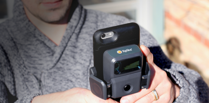
The accessibility of locations to a number of EPE’s facilities presents a potential safety risk and requires a strict safety protocol. Rich Castillo, System Administrator for EPE, was tasked with finding a solution that would allow EPE field personnel to measure objects and equipment from a distance and obtain a 3D image of its facilities. In this search for a solution, Rich Castillo attended the 2018 Esri Developer Summit in Palm Springs, California, which included a demonstration of Spike, a smart laser measurement solution, and Esri’s Survey123 for ArcGIS®. Immediately, Rich Castillo thought of EPE’s GIS Specialist, Alejandra Del Hierro, and the value Spike could provide to EPE.
Del Hierro recounts, “Rich [Castillo]came back from this summit and told me about this wonderful device and I got really excited. I’vebeen surveying and doing data collection for about 10 years, so for me the idea of having this small device that just attaches to my phone and gives me what I wanted… I knew I needed this device!” A week later, Castillo placed a Spike on her desk and said Thomas Bryant, an EPE Senior Project Manager, says “Merry Christmas”.
“It really was like Christmas morning. I downloaded the Spike app, put the Spike device on my phone and went outside. In utilizing Spike, I began to see how easily I could take measurements of the building and use different measurement features like Point-to-Point, as well as the ease of developing reports with all the details behind every picture,” continues Del Hierro.
Del Hierro immediately put Spike to use collecting measurements for a substation project, which involved 3 types of measurements. In addition to knowing the actual dimensions of the substation, they needed to know if there was room for equipment to be added to the substation and how they would add the equipment. She also used Spike to measure the transmission lines near the substations and collected supplementary measurements, such as the distance between poles.
“You can’t just walk into a substation and start taking measurements of the equipment there. Every time I walk in I can feel the electricity around me. With Spike, I don’t have to get close to any equipment to get the measurements. I can just take the pictures and then get the measurements,” explains Del Hierro.
Without Spike, Del Hierro would previously have to lug around her personal protective equipment (PPE), in addition to tools like her basic laser rangefinder or a measuring wheel. She would write everything down manually, then return to the office to have the team double check that she measured the right object and didn’t miss a measurement. Now with Spike, she has everything saved on her phone and if she needs clarification while at a substation, she just emails the Spike PDF file and gets the answers immediately.
Instead of taking hours to be at a substation to take measurements, she takes a few photos and is done, and doesn’t need to carry around additional equipment. The first time Del Hierro completed her measurements at a substation within minutes, everybody was shocked, because they had a full day originally scheduled for her survey.
Del Hierro is impressed she could get all the survey information from a Spike photo. “The detail that Spike gives you… the square footage, not to mention the distance and bearings, are all details you can’t get out of a picture or simple measurement. You’re also getting your X & Y values. All the information that you need.”

Now a committed advocate for Spike, Alejandra Del Hierro, EPE’s GIS Specialist, demonstrated Spike to Armando Reyes, an EPE Project Manager. Reyes quickly incorporated Spike into as many of his projects as he could, which were all in different stages of development.
During the scoping phase of a transmission project, Reyes uses Spike for ground measurements and GPS collection. He is required to follow right of way standards when scoping a location where EPE is going to run new transmission lines. He uses Spike to measure widths to see if they can fit a transmission line into a corridor and meet the required width for a right of way. Reyes uses the Spike photo and data to show the transmission construction management what the area looks like and the available space, so they can make decisions. GPS location captured with Spike is also very valuable data, as he can present a map with a conceptual line route.
Reyes uses Spike for more than just the scoping phase; he uses it during the construction phase of projects such as substation construction and transmission maintenance.
If Reyes is working on an active construction project, such as the construction of a new substation, then safety becomes a big concern. When on a substation construction site, field crew has a limited amount of space to work within, as substations have set footprints of where they need to be built. He wants to ensure that he’s not in people’s way, as you can easily put yourself in a dangerous position trying to measure manually with a tape measure or wheel, and equipment operators not seeing you. He uses Spike during the construction phase to verify construction is meeting the set plans. For example, ensuring that the grading equipment is reaching the edge of the site, or that the space between the end of the property and the fence line is correct. He finds that using Spike provides him with safety, efficiency, convenience, and time savings.
In discussing the ROI of Spike, Reyes believes “the act of taking measurements with Spike saves me 90% of time. It replaces long measuring tapes and measuring wheels, and having to go back to the office and draw on paper. I just snap some pictures and I’m done. Spike adds so much more versatility that you can’t get from other measurement tools.”

Another example of a construction project is transmission maintenance, where Reyes is responsible for assessing whether or not maintenance crews can safely access repair sites. Crews need to access the repair site with their equipment, such as boom trucks, and he needs to ensure that the boom truck can fit between the lines. He uses Spike to measure clearances, such as the clearance between poles and ground clearances.
When discussing previous methods for taking measurements for transmission maintenance, Reyes says, “if I wanted to take a measurement of the clearance from a conductor to the ground or any piece of equipment, previously a lineman had to be scheduled to complete the work, which pulled him from his assigned work, adding unnecessary costs. The lineman would use a hot stick and attach to the line and then give me measurements of clearances; and if I needed to take several measurements in one particular area, that could easily take up a person’s half day, if not most of the day. It’s a very inefficient process.” When comparing previous methods with Reyes current use of Spike, EPE has a positive ROI on Spike after just the cost savings of hiring a lineman for 1.5 days.
Other projects that EPE has used Spike on successfully is vegetation management where Thomas Bryant, Senior Project Manager with EPE, uses Spike to measure tree heights and distances from the lines. These types of projects come under federal control, meaning that detail and accuracy are extremely important. EPE did clear cutting in a project area, and used Spike to show that the distance away from the line to the next tree was clear. Then the compliance department took the photos and included them in their reports. The Spike photo record provided them with evidence of the before and after work should a project get audited.
Bryant believes that without Spike, those vegetation measurements wouldn’t have been possible. While experienced linemen are able to guess measurements, that won’t always be the case. EPE now has new field personnel joining the team who don’t have 20 or more years of experience, and can’t guess.
In the near future, Bryant hopes to deploy several more Spike units into his team so that they can each have a Spike as part of their field toolboxes for data collection.

For Ryan Cain, YESCO branch manager of the St. George, Utah office, conducting site surveys for signage work was traditionally an expensive process, … Continue reading "El Paso Electric Puts Safety First with Spike"
Celebrating six years of ISA Membership, seven years serving the sign and graphics industry, and over 50,000Spike users worldwide! Get the most valuable … Continue reading "El Paso Electric Puts Safety First with Spike"


Copyright © 2026 | ikeGPS.COM - All Rights Reserved.


 Connect
 Call
Call Support
 sign in
 IKE Value
  Meet our Team