


 Connect
 Call
Call Support
 sign in
 IKE Value
  Meet our Team
 “Using Spike and Survey123 with our iPads reduces time spent in the field collecting assets from months to minutes.”
Roberto AvilaPh.D., GIS Applications & Data Services Unit Manager, Colorado Department of Transportation
To our IKE Customers and Community, Like all businesses, we are continuing to monitor and respond to COVID-19. Our focus at IKE is on the health and well-being of our people, their families, andRead More
If you have ever had a great day fielding poles you have experienced the mental bliss that comes from a successful day in the field. This joy, while not often acknowledged, is what truly drivesRead More


Your time is important to us. We will be following up with you soon.
Until then, here are some resources you might find useful:
Sincerely,
Team IKE
Telephone, Email, Morse Code, or Smoke Signal
 303-222-3218
  [email protected]
1-720-381-1634
[email protected]
Need to measure
utility poles?You’re looking for IKE.
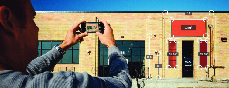
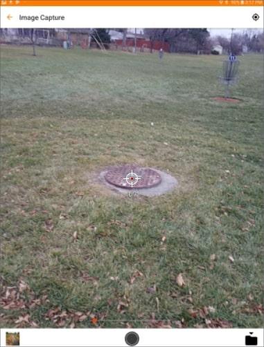
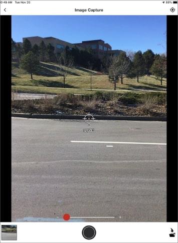
Spike is an award-winning compact laser beam measurement device that makes it simple for anyone to get correct and comprehensive measurements in imperial or metric units. It connects to the cloud using cellular data or a Wi-fi connection. Photos upload directly to a secure account where you can access them via web browser. All you need to do is snap a few quick photographs — and the Spike app does the rest
To purchase, click Buy Now above or visit our reseller directory.
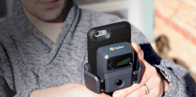
Spike is designed for users in the field. Spike pairs with a wide range of different sizes and models of Apple and Android smartphones and tablets using a Bluetooth connection and our dedicated app.
Several models are available, with options compatible with:
With the Spike laser, a compatible device, the Spike App and access to the Spike Cloud, one person can quickly get the measurements needed for signage design, permitting, quotes, planning and installation. Spike is the modern solution for gathering fast and accurate data regardless of project size or complexity, and it delivers multiple advantages that will benefit anyone:
Spike has its own battery. If your phone or tablet’s battery is charged, you’re ready to get to work measuring heights, widths, lengths, areas and target locations.
Spike is trusted by over 5,000 companies worldwide. The unit is maintenance-free, and each comes backed by a one-year product warranty. We also have a 30-day, no-questions-asked, money-back guarantee to ensure you’re completely satisfied with the product.
Spike is available for Smartphones, Tablets, and is even compatible with the OtterBox uniVERSE case system. Purchase your Spike today!
30-day money back guarantee
No app subscription
No maintenance fees
Quick ROI
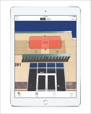
Measure your Spike photos on your desktop using the free Spike Web App:
Export as a JPG or PDF
Send a URL link

Carbon County, Utah’s use of Spike combined with Collector for ArcGIS for signage inventory was detailed in Esri’s quarterly publication of ArcNews. In the … Continue reading "Home"
Founded in 1901, El Paso Electric Company (EPE) is an electric utility providing generation, transmission, and distribution service to more than 400,000 retail … Continue reading "Home"
Ph.D., GIS Applications & Data Services Unit Manager, Colorado Department of Transportation
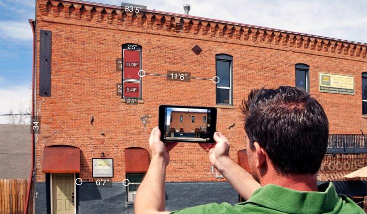
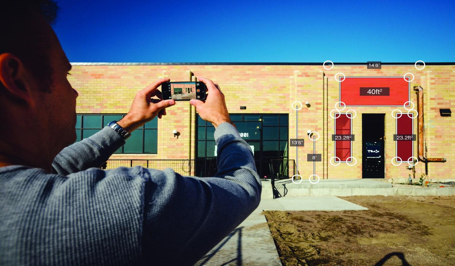
Achieve real-time measurements from a single photo. Measure elevations, lengths, and areas of objects along a single plane, such as walls, windows, or signs.
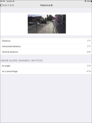
Measure the distance between two objects in seconds by capturing two photos. In addition to the distance measurement, Spike calculates the linear distance for vertical and horizontal measurements.
Capture a target’s location, your location, and a georeferenced image of the target, simply by taking a photo from a safe distance. Location data includes latitude, longitude, and altitude.
Measure the distance between your mobile device and the photographed object. This feature is useful for measuring setbacks, easements, and widths of objects.
30-day money back guarantee
No app subscription
No maintenance fees
Quick ROI
Wouldn’t it be great if site surveys and estimates didn’t drag down the sales process? Site surveys and estimates require a major investment … Continue reading "Home"
Founded in 1901, El Paso Electric Company (EPE) is an electric utility providing generation, transmission, and distribution service to more than 400,000 retail … Continue reading "Home"
Project Manager
El Paso Electric Company
Spike doesn’t require you to physically access the object you are measuring or manually input any measurements. It doesn’t even require a data connection, expect for when you are ready to export or upload your data. From a single photo, Spike captures a significant amount of data about your position and that of your target object. The Spike laser device connects via Bluetooth with your mobile device, and utilizes your smartphone or tablet’s camera, GPS, compass, and connection to the internet.
Spike works with Google Android and Apple iOS smartphones and tablets.
View a list of compatible devices that have gone through camera calibration procedure and provide the highest level of accuracy.
The accuracy of Spike’s laser rangefinder is ± 5cm (2in); the accuracy of Photo Measurements is ± 1%; and the accuracy of Point-to-Point Measurements is ± 3%. For additional information on optimal distances and angles, visit the Spike Support Center.
Spike’s eye safe laser rangefinder supports ranges between 6-650 feet (2-200 meters). The accuracy of Spike’s laser rangefinder is ± 5cm (2 in).
The Spike mobile app is free to download from the Google Play or Apple App Store. The Spike Cloud can be accessed from a browser, and has a Basic (free) plan or optional paid Pro plan.
Spike supports measurements in feet + inches, inches, meters, or centimeters. Unit settings may be changed at any time via the Spike app settings or Cloud settings.
Measurements are stored with the photo and from the Spike app the data can be shared as a PDF report, JPG, Spike File (XML), KMZ, URL, or Scaled Image or uploaded to the Spike Cloud. The Spike Cloud provides the following output options: JPG, Shareable URL, and PDF report.
The Spike device connects with your Smartphone or Tablet via Bluetooth. Your device must support BLUETOOTH 4.0 low energy technology.
The Spike device has an Internal Li-ion battery that is charged via a micro USB charging port (a USB cable is included in the box with Spike). Battery life is 4 hours of continuous use.
The Spike app and Cloud supports 16 languages. Visit the Spike Support Center for the full list.
ikeGPS is a leader in developing innovative solutions for rapidly obtaining accurate measurements, and we're proud to be your home for Spike laser measurement tools and product support. Our team knows our products and the industries that depend upon accurate measurements. We're happy to answer any questions you have about the product, explain our services and show you all the ways Spike will help you save time and money. Connect with us using our contact form, or give us a call at 1-844-4-IKEGPS.
30-day money back guarantee
No app subscription
No maintenance fees
Quick ROI
Founded in 1901, El Paso Electric Company (EPE) is an electric utility providing generation, transmission, and distribution service to more than 400,000 retail … Continue reading "Home"
GIS Manager
City of Roswell, Georgia
The Spike Partner Program enables leading software vendors to integrate with Spike’s mobile app, and bring Spike’s robust measurement and location technology to mobile field solutions. We offer several types of software integration, including APIs, SDKs, and XML. Contact us to learn more.
Contact Us
Spike is seamlessly integrated with Esri’s Survey123 for ArcGIS mobile app, enabling any field user to capture photos and measurements with Spike and a Survey123 mobile form. Spike measurements and photos are automatically populated into the form, and stored as GIS attributes in a geodatabase

Spike is integrated with AutoCAD by Autodesk, bringing Spike’s Photo Measurements to your day-to-day design work with AutoCAD. Instead of manually entering measurements into your designs, you can measure while designing using Spike’s Scaled Imaged.
Spike is partnered with OtterBox, the No. 1-selling smartphone case brand in the U.S. Their uniVERSE Case System helps businesses go mobile by enabling you to protect your smartphone or tablet and easily interchange important hardware tools like thermal cameras, bar code scanners, and battery packs. The uniVERSE case features a slotted rail that allows you to swap hardware modules on and off the back of an Apple or Android smartphone / tablet. We offer a Spike model dedicated to this case system so you can easily share Spike between mobile devices such as an iPhone 11, Samsung Galaxy S10, and iPad mini.
A smart laser measurement solution for all trade and construction professionals. The Spike device, Spike mobile app, Spike Cloud, and Kyocera DuraForce PRO 2 smartphone work together to change how you measure and estimate projects. Spike allows you to measure an object simply by taking a photo with your Kyocera DuraForce PRO 2 and Spike device. From that photo, you can capture real-time measurements, including height, width, area, and the distance between two points.
30-day money back guarantee
No app subscription
No maintenance fees
Quick ROI
A Recap of all the Spike News Announced During the Esri UC The Spike team exhibited at the 2019 Esri User Conference in … Continue reading "Home"
At the first OtterBox uniVERSE B2B Summit, ikeGPS and OtterBox introduced their new partnership and licensing agreement that delivers a new version Spike, … Continue reading "Home"
I.S. Project Coordinator
City of Winston-Salem, North Carolina
Geospatial professionals can greatly benefit from Spike’s measurement and location capabilities, and the integration with Esri mobile apps. Spike is used by more than 30% of state DOTs, as well as by federal, state and municipal organizations.
learn moreSpike is used by more than 5,000 signage professionals, and is the winner of the 2016 ISA International Sign Expo Innovation Award. Spike allows you to cut measurement and customer acquisition costs by more than 50%, and pays for itself in 3-5 site surveys.
learn moreMany field service industries require measurements and documentation of objects that are difficult to reach. Spike makes field operations safer, faster and more accurate. Industries from insurance to construction and architecture use Spike for their field mesurements.
learn more30-day money back guarantee
No app subscription
No maintenance fees
Quick ROI
Founded in 1901, El Paso Electric Company (EPE) is an electric utility providing generation, transmission, and distribution service to more than 400,000 retail … Continue reading "Home"
In speaking with Spike users at recent events and with partners, I’ve learned that the relatively new Point-to-Point Measurement feature on the Spike … Continue reading "Home"
Regional Office Administrator and Building Operations, Esri - Broomfield, Colorado


Copyright © 2026 | ikeGPS.COM - All Rights Reserved.
