

To our IKE Customers and Community, Like all businesses, we are continuing to monitor and respond to COVID-19. Our focus at IKE is on the health and well-being of our people, their families, andRead More
If you have ever had a great day fielding poles you have experienced the mental bliss that comes from a successful day in the field. This joy, while not often acknowledged, is what truly drivesRead More


Your time is important to us. We will be following up with you soon.
Until then, here are some resources you might find useful:
Sincerely,
Team IKE
Telephone, Email, Morse Code, or Smoke Signal
 303-222-3218
  [email protected]
1-720-381-1634
[email protected]
4 April 2018

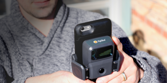
Roberto Avila, Ph.D. GIS Applications & Data Services Unit Manager with the Colorado Department of Transportation, spoke with Susan Smith from GISCafe Voice about their recent pilot of Esri’s Survey123 for ArcGIS and Spike.
According to Avila, “with a snap of the phone, you can measure in real time, height, weight, area, length, target location. Being able to record dimensions on the spot and share a photo with measurements makes it ideal for estimates for commercial and real estate projects, as well as facilities or assets.”
GISCafe.com is a digital news publication and web portal focused on providing GIS industry news.
Read the full article here from the interview with Roberto Avila, CDOT GIS Applications and Data Services Unit Manager.

For Ryan Cain, YESCO branch manager of the St. George, Utah office, conducting site surveys for signage work was traditionally an expensive process, … Continue reading "GISCafé Interviews Colorado DOT About Spike and Survey123 Pilot"
Celebrating six years of ISA Membership, seven years serving the sign and graphics industry, and over 50,000Spike users worldwide! Get the most valuable … Continue reading "GISCafé Interviews Colorado DOT About Spike and Survey123 Pilot"


Copyright © 2026 | ikeGPS.COM - All Rights Reserved.


 Connect
 Call
Call Support
 sign in
 IKE Value
  Meet our Team