

To our IKE Customers and Community, Like all businesses, we are continuing to monitor and respond to COVID-19. Our focus at IKE is on the health and well-being of our people, their families, andRead More
If you have ever had a great day fielding poles you have experienced the mental bliss that comes from a successful day in the field. This joy, while not often acknowledged, is what truly drivesRead More


Your time is important to us. We will be following up with you soon.
Until then, here are some resources you might find useful:
Sincerely,
Team IKE
Telephone, Email, Morse Code, or Smoke Signal
 303-222-3218
  [email protected]
1-720-381-1634
[email protected]
6 March 2018

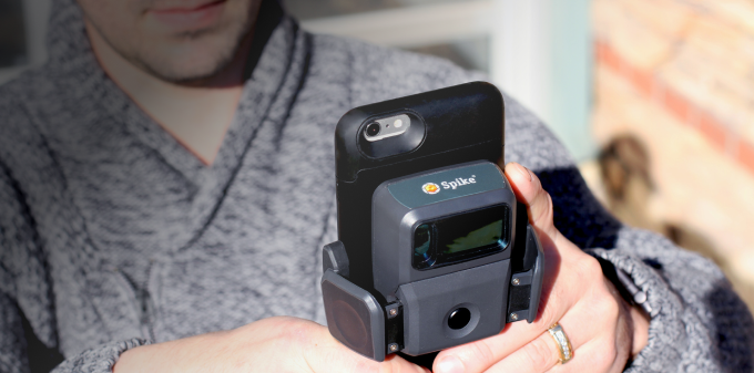
Use of the Survey123 integration with Spike will be of particular interest to organizations that routinely utilize mobile workflows for asset and facilities management, field asset inventories and inspections, damage assessments, and tactical operations including disaster response. Using Spike with Survey123 relieves fieldworkers of the burden of carrying paper maps to find the object of interest and lugging multiple pieces of specialized, expensive measuring equipment. Instead, with just a single mobile device, fieldworkers can locate the correct asset, record measurement data, and report accurate data directly back to the office.
“The new Spike integration with Survey123 is a game changer for many field data collection and inspection workflows where the dimension of physical objects needs to be captured. Spike and Survey123 provide quick return on investment,” said Ismael Chivite, Esri product management lead. “The simplicity of the solution enables it to be quickly deployed and with little training. Customers are very enthused about this low-cost solution that will streamline many of their critical workflows.”
With such an easy-to-use workflow, anyone can engage in field data collection activities. The ability to capture accurate measurements in the field is particularly useful when working in areas that don’t lend themselves to hands-on or close-up measurement. Spike’s laser can be used in ranges from 6 to 650 feet, with the option to select units of measurement in inches, feet, meters, or centimeters. With it, a single fieldworker is able to more quickly and safely accomplish what may otherwise have taken multiple field staff and costly equipment.
The Spike laser device mounts to smartphones and tablets and connects via Bluetooth with the mobile device’s camera. Survey123 with Spike runs on Apple iOS and Google Android smartphones and tablets.
To find out more about how Survey123 for ArcGIS with Spike can digitally transform your organization, visit spike.ikegps.com/esri-survey123/
About Esri
Esri, the global market leader in geographic information system (GIS) software, offers the most powerful mapping and spatial analytics technology available. Since 1969, Esri has helped customers unlock the full potential of data to improve operational and business results. Today, Esri software is deployed in more than 350,000 organizations including the world’s largest cities, most national governments, 75 percent of Fortune 500 companies, and more than 7,000 colleges and universities. Esri engineers the most advanced solutions for digital transformation, the Internet of Things (IoT), and location analytics to inform the most authoritative maps in the world. Visit us at esri.com.
Copyright © 2018 Esri. All rights reserved. Esri, the Esri globe logo, The Science of Where, ArcGIS, esri.com, and @esri.com are trademarks, service marks, or registered marks of Esri in the United States, the European Community, or certain other jurisdictions. Other companies and products or services mentioned herein may be trademarks, service marks, or registered marks of their respective mark owners.

For Ryan Cain, YESCO branch manager of the St. George, Utah office, conducting site surveys for signage work was traditionally an expensive process, … Continue reading "ikeGPS Announces Spike Integration with Esri’s Survey123 for ArcGIS"
Celebrating six years of ISA Membership, seven years serving the sign and graphics industry, and over 50,000Spike users worldwide! Get the most valuable … Continue reading "ikeGPS Announces Spike Integration with Esri’s Survey123 for ArcGIS"


Copyright © 2026 | ikeGPS.COM - All Rights Reserved.


 Connect
 Call
Call Support
 sign in
 IKE Value
  Meet our Team