

To our IKE Customers and Community, Like all businesses, we are continuing to monitor and respond to COVID-19. Our focus at IKE is on the health and well-being of our people, their families, andRead More
If you have ever had a great day fielding poles you have experienced the mental bliss that comes from a successful day in the field. This joy, while not often acknowledged, is what truly drivesRead More


Your time is important to us. We will be following up with you soon.
Until then, here are some resources you might find useful:
Sincerely,
Team IKE
Telephone, Email, Morse Code, or Smoke Signal
 303-222-3218
  [email protected]
1-720-381-1634
[email protected]
23 September 2019

The Federal Highway Administration (FHWA) and U.S. Department of Transportation (U.S. DOT) support the transfer of best practices and technical resources among State, regional, and local transportation organizations. With this in mind, the FHWA created a GIS in Transportation Program that facilitates the transfer of GIS skills and resources. The GIS in Transportation team publishes reports, hosts webinars, and shares newsletters to highlight case studies and best practices for the GIS and transportation communities.
The most recent report published by GIS in Transportation with the U.S. DOT Volpe National Transportation Systems Center is titled “Mobile Applications for GIS: Case Studies of Select Transportation Agencies”. This report is centered around five State DOTs and their use of mobile apps to collect and manage GIS asset data. By publishing this report, the FHWA hopes that other State DOTs can review and consider adopting the approach these five State DOTs took in order to reduce duplicate efforts and to gain efficiencies. In addition, according to the report “the Federal Highway Administration (FHWA) has been promoting the use of GIS among State DOTs to more efficiently manage the country’s transportation system.”
Through a survey conducted by the GIS in Transportation Program with the American Association of State Highway and Transportation Officials (AASHTO), five State agencies were identified as demonstrating experience in the field leveraging mobile technology. The five participating State agencies were: Colorado DOT, Kansas DOT, Kentucky Transportation Cabinet, Maryland DOT / State Highway Administration, and Missouri DOT.
On the topic of mobile hardware, the participating agencies stated that they use two categories of mobile field hardware, GPS/GNSS receivers and imaging devices. Example GPS receivers that were mentioned include the Geode by Juniper (compatible with Spike), several models of Trimble GPS receivers (some of which are compatible with Spike), and the GLO by Garmin. All of these GPS receivers can be connected to a mobile device via Bluetooth.
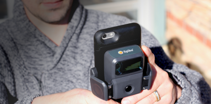
When sharing examples of imaging devices, both Colorado DOT and Maryland DOT / SHA reported using Spike. The report states that Spike “allows the agencies to take distance measurements and calculate the area of features in a photo after data has been collected in the field. For example, a GIS practitioner can use a photo of a railroad crossing taken with Spike GPS in the field, know exactly where the crossing is geospatially, and measure, for instance, the width of the right-of-way at the crossing.” With regards to software, all five agencies confirmed using both Esri’s Collector for ArcGIS and either Survey123 for ArcGIS or ArcGIS QuickCapture.
Colorado DOT has previously stated that they use Spike with Esri’s Survey123 for ArcGIS for asset management, and that the combined solution reduced their field time from months to minutes. See Colorado DOT video interview here.
Benefits that all of the participants reported from using mobile technology are “increased efficiency with which they can collect data and an increase in the quality of the data they collect. The benefits associated with the increased efficiencies include the time and cost savings achieved through more efficient means as well as a reduction in the duplication of efforts. Staff are able to collect data in the field more efficiently. (…) Furthermore, with the same levels of staffing, agencies can then collect more asset types for the same geographic area over the same amount of time.”
The full report “Mobile Applications for GIS: Case Studies of Select Transportation Agencies” can be downloaded from the GIS in Transportation website here.

For Ryan Cain, YESCO branch manager of the St. George, Utah office, conducting site surveys for signage work was traditionally an expensive process, … Continue reading "Spike included in Mobile Apps for GIS Report by FHWA, U.S. DOT"
Celebrating six years of ISA Membership, seven years serving the sign and graphics industry, and over 50,000Spike users worldwide! Get the most valuable … Continue reading "Spike included in Mobile Apps for GIS Report by FHWA, U.S. DOT"


Copyright © 2026 | ikeGPS.COM - All Rights Reserved.


 Connect
 Call
Call Support
 sign in
 IKE Value
  Meet our Team