

To our IKE Customers and Community, Like all businesses, we are continuing to monitor and respond to COVID-19. Our focus at IKE is on the health and well-being of our people, their families, andRead More
If you have ever had a great day fielding poles you have experienced the mental bliss that comes from a successful day in the field. This joy, while not often acknowledged, is what truly drivesRead More


Your time is important to us. We will be following up with you soon.
Until then, here are some resources you might find useful:
Sincerely,
Team IKE
Telephone, Email, Morse Code, or Smoke Signal
 303-222-3218
  [email protected]
1-720-381-1634
[email protected]
2 August 2017

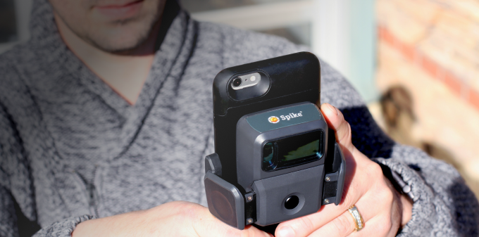
Collecting fast, safe and accurate measurements while in the field is a necessary and important task that all local governments face. For Carbon County, Utah, their GIS and Road Departments recently witnessed huge improvements in their field data collection processes when they started using Collector for ArcGIS with Spike – a mobile GIS and laser measurement solution.
Daniel Campbell is the Road Shop Supervisor and has been working for the Carbon County Road Department for 17 years. Although Campbell is with the Road Department, he understands the importance of GIS data and how collaborating with the GIS Department helps his unit run asset management projects more efficiently. One such task is signage inventory. Campbell is tasked with visiting each sign in the county annually to check and record its condition.
Striving for a more efficient process for signage inventory, Campbell turned to Mellissa Lasslo, a GIS Specialist who has been with Carbon County in the GIS Department for 9 years. Lasslo started using ArcGIS in college and has been using it for 11 years. She thinks she’s one of the biggest users in her department, and insists on staying up-to-date on her ArcGIS knowledge.
Lasslo had been looking for a way to capture the additional information needed to round out her GIS data, when she ran across Spike. She first heard of Spike while attending a presentation at the 2016 Utah Geographic Information Council. She was so impressed that she asked the speaker if she could borrow his Spike. It just so happened that during her testing there was flooding in Carbon County.
The flood was the first time that Lasslo and Campbell paired ArcGIS with Spike, and they were impressed with the results. They were able to measure washouts on the roads and culverts, which they used to calculate how much material would be needed for the repairs. In fact, at the time Carbon County was trying to get support from FEMA, and they were able to use this real-world documentation for FEMA, as well as give the engineering team insight into the projects and how to reengineer the culverts. Prior to the floods, Campbell hadn’t been collecting GPS or measurements of culverts. Today, his team now know what all the culverts look like, their measurements, materials and geo-location.
After using Spike during and after the flooding, Lasslo and Campbell knew that their departments could not go without having their own Spike. Campbell says that their experience during the flood was their “ah ha” moment about how they could scale their discovery of ArcGIS and Spike for signage inventory.
When it came time for the annual signage collection project, Campbell and his team found their current processes very time-consuming. Multiple devices were used to complete one task, such as a laptop, tape measure, GPS, camera, ladder, and generator. Due to multiple people collecting and no method for mapping the surveys, some signs were collected more than once.
As part of the annual inventory, team members were previously required to collect a sign’s GPS, write the coordinates down and then transfer the data to an Excel spreadsheet on a computer that was plugged into a field generator. Next, a photo was taken of the sign, then matched with the coordinating sign back at the office. Lastly, that photo had to be uploaded to Excel with field notes added.
This process was turned on its head once Campbell and Lasslo started using Collector for ArcGIS and Spike to complete signage inventory. Now Campbell sends two team members into the field, one person drives and the other does the measurement work. When the driver pulls up to a sign, the passenger opens up both the Collector for ArcGIS app and the Spike app. The passenger first marks the location of the sign with Collector, and then takes a photo of the sign by attaching the Spike laser device to an iPhone or Android smartphone. From the Spike mobile app, he also uploads the picture to the Spike Cloud so that additional measurements can be taken later back at the office.
Once the sign measurements have been taken using the Spike mobile app, the passenger creates a feature in Collector and attaches the Spike photo and adds any necessary notes about the condition of the sign. This includes the measurements taken using Spike. Additionally, Lasslo appreciates that multiple photos can be added to a feature in Collector. Once a sign is repaired, a new Spike photo is then attached to the feature in Collector, making the full sign history complete with photo documentation easily accessible.
As part of her role, Lasslo is responsible for collecting and updating data, data summary and map outputs. This signage inventory project was the first time she started using Collector for ArcGIS for Campbell’s annual project. The reason she selected Collector was because Campbell’s team could use it offline, through the tile package. Campbell’s team needed to cache maps of the entire county, which could be accomplished by creating a tile package. With the tile package, Campbell’s team can be disconnected and still have access to maps of the whole county with the road names.
Using their old methods, Campbell and his team used to take 5-weeks to inventory 1,500 signage and spent approximately $50,000 annually. Since successfully implementing Collector with Spike into their signage inventory processes with Lasslo’s support, Campbell’s team was able to collect 322 signs per day or 1,620 in a one-week period. What once cost $50,000 was reduced to $5,000. That amounts to a staggering 568% ROI on Carbon County’s most recent annual sign collection.
According to Lasslo, Collector and Spike have significantly impacted how the GIS and Road Departments capture field data. “With this new process combining Collector for ArcGIS with Spike, we have been able to collect, measure and store our data more efficiently. We have saved time and money. Now we can have multiple people collecting and editing data at the same time and be able to see it live as it is collected,” says Lasslo.
Campbell adds, “When Melissa approached me about testing Spike with Collector for road sign inventory, I was excited to try it. We were behind on our sign program because it was so expensive and time-consuming to go around and collect the data. Melissa figured out how to make the two programs talk to one and other and work offline, which was tremendous for us because we’re so remote. We collected data on 322 signs in Nine Mile Canyon without any service. Once we were back in-range, all the data was there. What used to take us six months to collect, now only takes us weeks” he says.
In fact, the powerful solution of Collector and Spike is used on more than just flood assessment and signage collection projects. Carbon County is successfully using their Spike to measure trench length & depth, diameters of culverts, widths of road surface, widths of sidewalks, lengths of drainage ditches, road failures, vegetation encroachments in road right of ways, stockpiles, road encroachments, overlay projects, compaction, and utility marks after culvert installation. Campbell and his team use a lot of oversized equipment, and the Utah Department of Transportation makes them apply for a permit and plan out a route. Now they can quickly and easily plan those routes by reviewing their assets in Collector and reviewing the attached Spike photo with measurements.
Visit our Spike product page to see how Spike can help you work more efficiently and save on your bottom line.

For Ryan Cain, YESCO branch manager of the St. George, Utah office, conducting site surveys for signage work was traditionally an expensive process, … Continue reading "Spike Stories: Carbon County, Utah Sees a Staggering Return on Investment from Collector ArcGIS and Spike"
Celebrating six years of ISA Membership, seven years serving the sign and graphics industry, and over 50,000Spike users worldwide! Get the most valuable … Continue reading "Spike Stories: Carbon County, Utah Sees a Staggering Return on Investment from Collector ArcGIS and Spike"


Copyright © 2026 | ikeGPS.COM - All Rights Reserved.


 Connect
 Call
Call Support
 sign in
 IKE Value
  Meet our Team