

To our IKE Customers and Community, Like all businesses, we are continuing to monitor and respond to COVID-19. Our focus at IKE is on the health and well-being of our people, their families, andRead More
If you have ever had a great day fielding poles you have experienced the mental bliss that comes from a successful day in the field. This joy, while not often acknowledged, is what truly drivesRead More


Your time is important to us. We will be following up with you soon.
Until then, here are some resources you might find useful:
Sincerely,
Team IKE
Telephone, Email, Morse Code, or Smoke Signal
 303-222-3218
  [email protected]
1-720-381-1634
[email protected]
6 July 2018

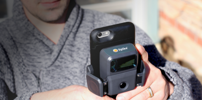
In the United States, local governments are responsible for surveying their ground signs for compliance on a regular basis and keeping a detailed record of the history of the sign. This is no small task for a city to accomplish, and is typically time and cost-consuming. The Zoning Department with the City of Winston-Salem, North Carolina, was getting ready to start their signage inventory project, due to a new sign ordinance, when they discovered Spike.
Jeff Vaughn, the Zoning Inspection Supervisor with the City of Winston-Salem, says that they were initially going to hire land surveyors to complete the project, but ultimately decided to use Spike and their own staff for this assignment after speaking with a local sign company that was successfully using Spike. That sign company lent Vaughn their Spike for testing, and after quickly seeing how easy it was to measure the height and square footage of a sign, the city ordered their own Spike units. They initially started with one Spike and then quickly ordered more as they developed their workflows.
Equipped with Spike units and iPads, Vaughn’s team was able to collect, review, and verify compliance on 3,000 signs in less than three months. They developed a process with a team of six in-house employees across departments, which involved going to every ground sign not attached to a building in the city.
As part of that survey process for this project, Christopher Sparks, I.S. Project Coordinator with the City of Winston-Salem, and Vaughn’s team worked with their GIS department. According to Sparks, “the GIS team wrote a script that took the Spike files and imported them into Esri’s ArcGIS so we could capture all attribute data.” With a Spike photo, Vaughn’s team was not only able to capture measurement data, but also the GPS location of a sign.
Once positioned at a sign, a field inspector would take out an iPad with a Spike attached, and take a photo of the sign. In fact, the department’s record during the project was 150 photos of signs captured in one day with Spike. When back at the office the next day, an inspector, or Vaughn, would then take area and height measurements of the sign using the Spike mobile app, export a Spike XML file with photos to OneDrive, run the GIS script, and lastly import the photo with the measurement and location data into ArcGIS Online.
The photo and data would be reviewed on the map and marked as to whether or not the sign was compliant with zoning. Vaughn’s group reviewed every single sign, and marked it as quality assured (QA). They would follow by running another check making sure the sign was assigned to the correct property owner and correct zoning regulation, and generate a final report listing if a sign was compliant or not.
“The amount of time saved was greater for us because we didn’t have to hire land surveyors to go out and do the work. We also had tremendous cost savings by using Spike and using employees rather than an outside vendor, which could have cost $200,000-500,000 to inventory every sign in the city,” explains Vaughn. In fact, Vaughn and Sparks estimate that their hardware costs for this inventory project was less than $5,000.
According to Sparks, “from an IT perspective the project was a success. Spike and ArcGIS let Vaughn and his team accomplish what they needed to do. We now have a comprehensive sign inventory. Since the signs mostly belong to commercial properties, and they are not required to be in compliance until 2022, we can change a flag on the back end in ArcGIS, redo the intersect, update property owners, and notify the new owners. We have something in place that will last for a while.”
Vaughn and Sparks recommend Spike and ArcGIS to other cities and zoning departments. Vaughn believes that this solution “certainly helped us from an enforcement perspective, because we have an accurate count of the signs in the city and also an inventory for them. We can always see a photo of the sign and the history. We have several people who have changed signs without a sign permit, so Spike and ArcGIS have been helpful when we have to go back and enforce measurement. We can show what the sign looked like on one date and then prove how the sign was different on a later date.”
The zoning team is now using Spike on other projects. For example, they take Spike photos for all new ground signs, and then incorporate the photo and measurement and location data into ArcGIS to catalog the sign’s record. In this way, they always have a current inventory of all the signs in the city. They also plan to use Spike for measuring light poles and building heights to check compliance on height restrictions.
Visit our Spike product page to see how Spike can help you work more efficiently and save on your bottom line.

For Ryan Cain, YESCO branch manager of the St. George, Utah office, conducting site surveys for signage work was traditionally an expensive process, … Continue reading "Spike Stories: City of Winston-Salem Zoning Team Cuts Costs on Sign Inventory & Compliance"
Celebrating six years of ISA Membership, seven years serving the sign and graphics industry, and over 50,000Spike users worldwide! Get the most valuable … Continue reading "Spike Stories: City of Winston-Salem Zoning Team Cuts Costs on Sign Inventory & Compliance"


Copyright © 2026 | ikeGPS.COM - All Rights Reserved.


 Connect
 Call
Call Support
 sign in
 IKE Value
  Meet our Team